
Page 28 - IJPS-6-1
P. 28
Inequalities in urban exposure in million-plus cities of India
A
B
C
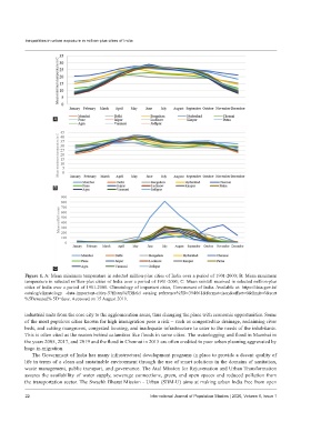
Figure 1. A: Mean minimum temperature in selected million-plus cities of India over a period of 1901-2000; B: Mean maximum
temperature in selected million-plus cities of India over a period of 1901-2000; C: Mean rainfall received in selected million-plus
cities of India over a period of 1901-2000. Climatology of important cities, Government of India. Available at: https://data.gov.in/
catalog/climatology -data-important-cities-5?filters%5Bfield_catalog_reference%5D=394661&format=json&offset=0&limit=6&sort
%5Bcreated% 5D=desc. Accessed on 15 August 2019.
industrial units from the core city to the agglomeration areas, thus changing the place with economic opportunities. Some
of the most populous cities known for high immigration pose a risk – such as congested/no drainage, reclaiming river
beds, and cutting mangroves, congested housing, and inadequate infrastructure to cater to the needs of the inhabitants.
This is often cited as the reason behind calamities like floods in some cities. The waterlogging and flood in Mumbai in
the years 2005, 2017, and 2019 and the flood in Chennai in 2015 are often credited to poor urban planning aggravated by
huge in-migration.
The Government of India has many infrastructural development programs in place to provide a decent quality of
life in terms of a clean and sustainable environment through the use of smart solutions in the domains of sanitation,
waste management, public transport, and governance. The Atal Mission for Rejuvenation and Urban Transformation
assures the availability of water supply, sewerage connections, green, and open spaces and reduced pollution from
the transportation sector. The Swachh Bharat Mission - Urban (SBM-U) aims at making urban India free from open
22 International Journal of Population Studies | 2020, Volume 6, Issue 1