
Page 38 - IJPS-6-1
P. 38
Managing natural disaster risk with earthquake damage scenarios
Wald, 2008). Federal and State Governments have initiated several programs from time to time to manage disasters, as well as
to mitigate their adverse impacts. However, assessment of the effectiveness of these programs to mitigate earthquake risk was
never done due to the lack of scientifically valid EDS (Meena, Shinde, Sapre, et al., 2013; Sinha, Goyal, Murty, et al., 2014).
To understand the direct and indirect consequences of high magnitude earthquake and needed preparedness of
administration for it, NDMA initiated a study to develop a multi-state earthquake disaster scenario for a hypothetical
earthquake of moment magnitude 8.0. Indian Institute of Technology (IIT), Bombay, and Madras undertook this scientific
exercise to develop earthquake scenarios for the Northwest Himalayan Region. The epicenter of the hypothetical
earthquake was planned in a “seismic gap” in western Himalaya and several scientists expect this region to experience
a large earthquake soon. The project was undertaken in the states of Punjab, Haryana, Himachal Pradesh, and Union
Territory of Chandigarh, considering the high level of seismic vulnerability (seismic zone III to V) in the Himalayan belt
(Sinha, Goyal, Murty, et al., 2014).
The earthquake scenario developed under the project involved as many as 32 stakeholders ranging from various
government agencies at federal, state and local levels, defense organizations, and academic institutions, including schools,
colleges, and non-government organizations with well-defined responsibilities. The EDS development team was led by
the NDMA, consisted of scientific experts in the field of earthquake engineering (from IIT Bombay and IIT Madras).
Representatives from Himachal Pradesh, Haryana, Punjab, state governments, and Union Territory of Chandigarh were
also involved in the project. Inputs were also sought from organizations involved in earthquake monitoring, hazard
assessment, and managing major infrastructure or facilities in the affected region such as IMD, Geological Survey of India,
Border Roads Organisation, Central Water Commission, and Bhakra Beas Management Board. A part of seismotectonic
information for the Western Himalayan was provided by the Wadia Institute of Himalayan Geology. The project team also
includes a Coordination Agency (namely, Geo-Hazards Society India) to facilitate the coordination between the various
stakeholders, particularly at the state level. Software RISK.iitb v3.1 developed by IIT, Bombay, for integrated seismic
hazard, vulnerability, and risk assessment was used for simulations in Mandi EDS (Sinha, Aditya, Gupta, et al., 2008).
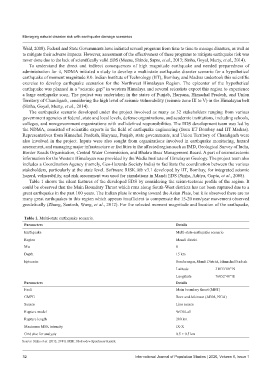
Table 1 shows the silent features of the developed EDS by considering the seism-tectonic profile of the region. It
could be observed that the Main Boundary Thrust which runs along South-West districts has not been ruptured due to a
great earthquake in the past 100 years. The Indian plate is moving toward the Asian Plate, but it is observed there are no
many great earthquakes in this region which appears insufficient to compensate the 15-20 mm/year movement observed
geodetically (Zhang, Santosh, Wang, et al., 2012). For the selected moment magnitude and location of the earthquake,
Table 1. Multi-state earthquake scenario.
Parameters Details
Earthquake Multi-state earthquake scenario
Region Mandi district
Mw 8
Depth 15 km
Epicenter Sundernagar, Mandi District, Himachal Pradesh
Latitude 31033’00” N
Longitude 76052’48” E
Parameters Details
Fault Main boundary thrust (MBT)
GMPE Bore and Atkinson (AB08, NGA)
Source Line source
Rupture model WC84-all
Rupture length 200 km
Maximum MSK intensity IX-X
Grid size for analysis 0.5 × 0.5 km
Source: Sinha et al. (2012, 2014). MSK: Medvedev-Sponheuer-Karnik.
32 International Journal of Population Studies | 2020, Volume 6, Issue 1