
Page 48 - JCAU-5-4
P. 48
Journal of Chinese
Architecture and Urbanism Learning from the countryside
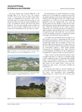
The most common type of rural settlement in the The development and spatial distribution of Linpan
Chengdu Plain is the “Lin Pan” form. The character settlements in the Chengdu Plain are greatly influenced by
“Lin (林)” means “forest,” and “Pan (盘)” means “plate.” the ancient Dujiangyan dam and its irrigation system. This
Linpan is a residential form that refers to both a small UNESCO World Heritage site features an irrigation water
residential unit and an entire settlement system. In each system that is over 2,200 years old and supports thriving
Linpan unit, there is at least one family household at the agriculture across the Chengdu Plain. As a result, the
center, surrounded by bamboo and other local arbors region’s settlements have adopted a scattered and flexible
(Figure 9). The outer layer typically consists of fields and mode of housing, with the Linpan being the most common
rivers. The word “Linpan” vividly portrays the form and type. Within the framework of this irrigation system,
pattern of the residential space (Ji, 2015; Shu et al., 2013). towns in the area are densely distributed on a small scale,
while numerous rural settlements are evenly scattered
throughout the region. The overall urban-rural continuum
structure in Chengdu can be seen as a residential network
consisting of variously sized Linpan settlements.
A translated map, published by the Army Map Service
and created by the Corps of Engineering in 1958, reveals
an evenly distributed pattern of cities and towns across the
Chengdu Plain (Figure 10). The majority of these towns
and cities align with the direction of the water system and
are interconnected by roads that either parallel or intersect
the watercourses, forming a stable spatial network.
Consequently, the Dujiangyan water system functions
Figure 7. Proposal of a new secondary school in Ling Hu Village. as the foundational environment for the development of
Source: Meriggi, 2015, 2017; Acuto & Meriggi, 2023, p. 176–177 Chengdu’s urban-rural continuum structure (Fang, 2012).
To gain a better understanding of the scattered nature
of Linpan settlements, we conducted a thorough analysis
of their configuration logic by examining their satellite
images. Our investigation focused on the morphology
of these settlements and classified them into five distinct
types based on the natural factors influencing their
composition: camp, stream, concentration, meander, and
line (Figure 11).
The research area, located in the Pidu District, lies
between the Dujiangyan Irrigation System and Chengdu.
Figure 8. Proposal of new housing compound in Xiang Ling Village. The district has experienced rapid urbanization,
Source: Meriggi, 2017; Meriggi, (with Belli), 2023, p. 158–159 transforming from a rural county into a thriving urban
A B
Figure 9. (A) The view of the Linpan landscape. (B) The composition of one Linpan settlement unit. Source: (A) Photograph by Mao Lin. (B) Lin, 2021
Volume 5 Issue 4 (2023) 9 https://doi.org/10.36922/jcau.0981