
Page 49 - JCAU-5-4
P. 49
Journal of Chinese
Architecture and Urbanism Learning from the countryside
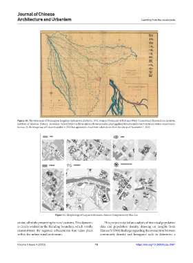
Figure 10. The water map of Dujiangyan Irrigation System was plotted in 1932. Source: Document of National Water Conservancy Bureau from Archives,
Institute of Modern History, Academia Sinica (https://archives.sinica.edu.tw/en/index.php/nggallery/thumbnails?project=national-water-conservancy-
bureau-2); the image was still downloadable in 2018 but appeared to have been taken down from the site as of November 1, 2023
Figure 11. Morphology of Linpan settlements. Source: Compilation by Mao Lin
center, all while preserving its rural customs. This dynamic This project entailed an analysis of historical population
is clearly evident in the blending boundary, which vividly data and population density, drawing on insights from
demonstrates the regional urbanization that takes place Skinner’s (1964) findings regarding the connection between
within the urban-rural continuum. community density and hexagonal radii to determine a
Volume 5 Issue 4 (2023) 10 https://doi.org/10.36922/jcau.0981