
Page 53 - JCAU-5-4
P. 53
Journal of Chinese
Architecture and Urbanism Learning from the countryside
Figure 15. Left panel: The seawall rivers (Tang) and canals (Pu). Right panel: The morphological features of the Cixi area are shaped by seawalls, canals,
and settlements. Source: Compilation by Chen & Chu, 2021
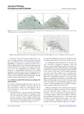
Figure 16. Market distribution in the Cixi area during the 1930s (left panel) and 1980s (right panel). Source: Compilation by Chen & Chu, 2021
This project views the structure of the seawall in the structure, the establishment of Skinner’s model can reveal
12
area as a lasting framework. This framework is connected the underlying structure of the settlement in the Cixi area.
not only to history and memory but also demonstrates its By combining the information from Cixi Shi Zhi (Cixi
adaptability to contemporary production models such as Local Chronicles Compilation Committee, 1992) and
Taobao Village. Based on the urban-rural continuum, this
study elucidates how the endurance of seawalls is manifested historical maps, the map (Figure 16) depicts the locations of
in the Cixi area, progressing from settlement cluster the markets in the 1930s and 1980s. Skinner’s model mapping
structures to morphological characteristics to building is obtained by creating Voronoi diagrams using the markets
typologies at different scales, achieved through the use of as the centers on the maps. The two panels underscore
Skinner’s model, morphology analysis, and fieldwork. As a the decisive role of the seawall system in influencing the
result, this project addresses this enduring aspect through distribution of the market. The recorded markets’ locations
an urban design proposal based on the research. align with the distribution direction of the seawalls. This
alignment is attributed to the high salt content of the Sanbei
3.3.1. Skinner’s model of the Cixi area according to the Plain’s soil. Historically, the area north of the Dagu seawall
market system in the Cixi region was predominantly engaged in cotton
The current settlement morphology pattern in the Cixi cultivation. The transportation of cotton outward and grain
area demonstrates a tendency to spread, blurring the inward required a canal system (Geng, 2022).
distinction between urban and rural structures due to Following central place theory, which is grounded in the
rapid urbanization. At the scale of settlement cluster concept of the most efficient transportation, it is established
that each high-level market contains four low-level
12 The project is based on Chen Kan and Chu Xiao’s Master’s markets (k = 4). After analyzing the area data in Figure 16,
degree thesis (2021), supervised by M. Meriggi. In 2022,
Chu Xiao extended the research through fieldwork and the standard hexagon model (standard Skinner’s Model) is
interviews in Kandun Taobao Villages, including Yulan formulated based on the mode of k = 4. This model, which
Fruit and Vegetable Farm, Peninsula Flower Farm, Qingting elucidates the relationship between higher- and lower-
Garden Farm, and Tian Shangjin Flowers. Part of the field level municipalities, confirms the reliability of the system
research findings are published in Meriggi et al., 2022. through an overlay with satellite images from the 1980s.
Volume 5 Issue 4 (2023) 14 https://doi.org/10.36922/jcau.0981