
Page 78 - JCAU-6-1
P. 78
Journal of Chinese
Architecture and Urbanism Virtual reconstruction of archaeological sites
A C
B
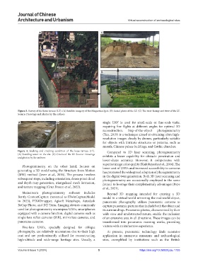
Figure 3. Survey of the loess terrace (LT). (A) Satellite imagery of the Maquetian Spot. (B) Aerial photo of the LT. (C) The west-facing-east view of the LT.
Source: Drawings and photos by the authors
A B single UAV is used for small-scale or fine-scale tasks,
requiring five flights at different angles for optimal 3D
reconstruction. Nap-of-the-object photogrammetry
(Yan, 2019) is a technique aimed at obtaining ultra-high-
resolution images closely by drones, particularly suitable
for objects with intricate structures or patterns, such as
murals, Chinese palace buildings, and Gothic churches.
Figure 4. Soaking and cracking condition of the loess terrace (LT). Compared to 3D laser scanning, photogrammetry
(A) Standing water on the site. (B) Cracks of the LT. Source: Drawings exhibits a lesser capability for obstacle penetration and
and photos by the authors
lower-shape accuracy. However, it compensates with
superior image color quality (Kadobayashi et al., 2004). The
Photogrammetry, on the other hand, focuses on lower cost of UAVs and increased accessibility to cameras
generating a 3D model using the Structure from Motion has promoted the widespread adoption of photogrammetry
(SfM) method (Jover et al., 2016). The process involves in the digital twin generation. Both 3D laser scanning and
subsequent steps, including orientation, dense point cloud photogrammetry are occasionally employed in the same
and depth map generation, triangulated mesh formation, project to leverage their complementary advantages (Pepe
and texture mapping (Cruz Franco et al., 2022). et al., 2021).
Mainstream photogrammetry software includes Beyond 3D mapping intended for creating a 3D
Bently ContextCapture (renamed as ITwinCaptureModel model in a virtual world mirroring the real-world object,
in 2023), PIX4Dmapper, Agisoft Metashape, Autodesk panoramic photography utilizes panoramic cameras to
ReCap Photo, and DJI Terra. Imaging devices commonly capture panoramic pictures that include both the object and
used for photogrammetry encompass UAVs, smartphones its surroundings. Panoramic photos, characterized by their
equipped with a camera function, digital cameras such as wide view and unobstructed nature, enable the inclusion
single-lens reflex cameras (SLR), mirrorless cameras, and of an extensive area in all directions. These images can be
panorama cameras. transformed into panoramic roaming works, providing
Five-lens UAVs, specially designed for oblique visitors with an immersive experience.
photography, are relatively uncommon due to their high At present, panoramic technology finds extensive
cost and are predominantly utilized for reconstructing application in numerous museums and archaeological
high-altitude and wide-range heritage sites. Usually, a sites, exemplified by institutions such as the British
Volume 6 Issue 1 (2024) 5 https://doi.org/10.36922/jcau.1735