
Page 82 - JCAU-6-1
P. 82
Journal of Chinese
Architecture and Urbanism Virtual reconstruction of archaeological sites
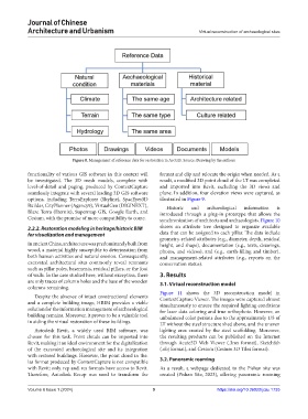
Figure 8. Management of reference data for restoration in ArcGIS. Source: Drawing by the authors
functionality of various GIS software in this context will format and clip and relocate the origin when needed. As a
be investigated. The 3D mesh models, complete with result, a modified 3D point cloud of the LT was completed
level-of-detail and paging, produced by ContextCapture and imported into Revit, excluding the 3D views and
seamlessly integrate with several leading 3D GIS software plane. In addition, four elevation views were captured, as
options, including TerraExplorer (Skyline), SpacEyes3D illustrated in Figure 9.
Builder, CityPlanner (Agency9), VirtualGeo (DIGINEXT), Historic and archaeological information is
Blaze Terra (Eternix), Supermap GIS, Google Earth, and introduced through a plug-in prototype that allows the
Cesium, with the promise of more compatibility to come. synchronization of architects and archaeologists. Figure 10
2.2.2. Restoration modeling in heritage/historic BIM shows an attribute tree designed to organize available
for visualization and management data that can be assigned to each pillar. The data include
geometry-related attributes (e.g., diameter, depth, residual
In ancient China, architecture was predominantly built from height, and shape), documentation (e.g., texts, drawings,
wood, a material highly susceptible to deterioration from photos, and videos), and (e.g., earth-filling and timber),
both human activities and natural erosion. Consequently, and management-related attributes (e.g., reports on the
excavated architectural sites commonly reveal remnants conservation status).
such as pillar poles, basements, residual pillars, or the foot
of walls. In the case studied here, without exception, there 3. Results
are only traces of column holes and the base of the wooden 3.1. Virtual reconstruction model
columns remaining.
Figure 11 shows the 3D reconstruction model in
Despite the absence of intact constructional elements ContextCapture Viewer. The images were captured almost
and a complete building image, HBIM provides a viable simultaneously to ensure the required lighting conditions
solution for the information management of archaeological for laser data coloring and true orthophoto. However, an
building remains. Moreover, it proves to be a valuable tool unbalanced color persists due to the approximately 1/5 of
in aiding the virtual restoration of these buildings. LT without the steel structure shed above, and the uneven
Autodesk Revit, a widely used BIM software, was lighting area created by the steel scaffolding. Moreover,
chosen for this task. Point clouds can be imported into the resulting products can be published on the Internet
Revit, making it an ideal environment for the digitalization through Acute3D Web Viewer (.3mx format), Sketchfab
of the excavated archaeological site and its integration (.obj format), and Cesium (Cesium 3D Tiles format).
with restored buildings. However, the point cloud in the.
las format produced by ContextCapture is not compatible 3.2. Panoramic roaming
with Revit; only. rcp and. rcs formats have access to Revit. As a result, a webpage dedicated to the Pishan site was
Therefore, Autodesk Recap was used to transform the created (Pishan Site, 2023), offering panoramic roaming
Volume 6 Issue 1 (2024) 9 https://doi.org/10.36922/jcau.1735