
Page 85 - JCAU-6-1
P. 85
Journal of Chinese
Architecture and Urbanism Virtual reconstruction of archaeological sites
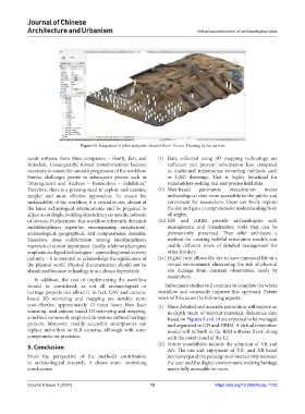
Figure 13. Integration of pillar and point cloud in Revit. Source: Drawing by the authors
needs software from three companies – Bently, Esri, and (i) Data collected using 3D mapping technology are
Autodesk. Consequently, format transformations become sufficient and prevent information loss compared
necessary to ensure the smooth progression of the workflow. to traditional information recording methods such
Similar challenges persist in subsequent phases such as as CAD drawings. This is highly beneficial for
“Management and Analysis – Restoration – Exhibition.” stakeholders seeking real and precise field data.
Therefore, there is a pressing need to explore and examine (ii) Web-based panoramic visualization makes
simpler and more effective approaches. To ensure the archaeological sites more accessible to the public and
sustainability of the workflow, it is crucial to stay abreast of convenient for researchers. Users can freely explore
the latest technological advancements and be prepared to the site and gain a comprehensive understanding from
adjust accordingly, avoiding dependency on specific software all angles.
or devices. Furthermore, this workflow inherently demands (iii) GIS and HBIM provide archaeologists with
multidisciplinary expertise, encompassing architectural, management and visualization tools that can be
archaeological, geographical, and computational domains. permanently preserved. They offer architects a
Therefore, close collaboration among interdisciplinary method for creating faithful restoration models and
experts is of utmost importance. Finally, while we place great enable different levels of detailed management for
emphasis on digital technologies – a prevailing trend in every other insiders.
industry – it is essential to acknowledge the significance of (iv) Digital twin allows the site to have immortal life in a
the physical world. Physical documentation should not be virtual environment, eliminating the risk of physical
abandoned because technology is not always dependable. site damage from constant observation needs by
researchers.
In addition, the cost of implementing the workflow
should be considered, as not all archaeological or Subsequent studies will continue to complete the whole
heritage projects can afford it. In fact, UAV and camera- workflow and constantly improve this approach. Future
based 3D surveying and mapping are notably more work will focus on the following aspects:
cost-effective, approximately 10 times lower, than laser (i) More detailed and accurate restoration will require an
scanning- and camera-based 3D surveying and mapping, in-depth study of relevant materials. Reference data
a method commonly employed in various cultural heritage based on Figures 8 and 10 are expected to be managed
projects. Moreover, readily accessible smartphones can and organized in GIS and HBIM. A virtual restoration
replace mirrorless or SLR cameras, although with some model will be built in the BIM software Revit, along
compromise on precision. with the point cloud of the LT.
5. Conclusion (ii) Future possibilities include the adoption of VR and
AR. The use and enjoyment of VR- and AR-based
From the perspective of the method’s contribution devices expand the paradigms of interactivity between
to archaeological research, it draws some interesting the user and the digital environment, making heritage
conclusions: assets fully accessible to users.
Volume 6 Issue 1 (2024) 12 https://doi.org/10.36922/jcau.1735