
Page 81 - JCAU-6-1
P. 81
Journal of Chinese
Architecture and Urbanism Virtual reconstruction of archaeological sites
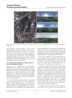
Figure 7. Left panel: The work plan of the Pishan site. Top-, middle-, and bottom-left panels: Examples of collected scans. Source: Drawings and photos
by the authors
This discrepancy can be attributed to factors such as terrain, and hydrology. The second type involves first-hand
building times or materials. Buildings constructed of information from the excavation site and other sites of the
stone, predominantly found in Europe, tend to be better same age, type, and area as the target site. The third type
preserved, while those made of wood, more prevalent in encompasses historical material, containing architectural
Asia, may only have foundations and pillars or pillar holes and cultural history materials related to the target site.
identifiable through archaeological methods. Modeling These data manifest in various formats, such as
archaeological remains without intact figures poses a photos, drawings, videos, documents, and models. The
significant challenge, and its application is hindered by management of this diverse array of data occurs within
stakeholders who deem it unnecessary.
the framework of ArcGIS, utilizing its comprehensive set
2.2.1. Information management and geo-analysis in of toolboxes. Within the ArcGIS environment, users can
the GIS for building restoration swiftly query and filter the organized information.
Architecture is an essential aspect of people’s lives, Incorporating altitude data recorded in documentation
influenced by both natural and cultural conditions. alongside the modern ground digital elevation model
Interdisciplinary material collected and analyzed on a single (DEM), an ancient ground elevation model is simulated.
platform is always beneficial. Therefore, the information This approach enables the inference of the evolution history
management and visual analysis functions of ArcGIS of environmental elements, such as ancient landforms and
make sense. The Pishan site represents a typical human hydrology. The arranged information accelerates the initial
settlement located at the foot of a hill and surrounded by speculation, encompassing structure, function, and layout,
water, making the environment simulation and analysis of fostering a quicker and more scientifically informed
that time more meaningful. approach. Subsequently, detailed restoration modeling,
incorporating parametric information, is undertaken
To achieve the ultimate goal of architectural restoration,
numerous supporting data need to be collated and within the framework of BIM. It’s worth noting that the
current terrain-based analysis is limited due to the absence
organized. Figure 8 displays reference data for restoration, of collected surrounding geographic data.
with three essential types of documentation. The first type
comprises the natural environment, directly recorded in the To further enhance the restoration process, additional
literature about the archaeological site, including climate, GIS software can be explored for their utility. The
Volume 6 Issue 1 (2024) 8 https://doi.org/10.36922/jcau.1735