
Page 83 - JCAU-6-1
P. 83
Journal of Chinese
Architecture and Urbanism Virtual reconstruction of archaeological sites
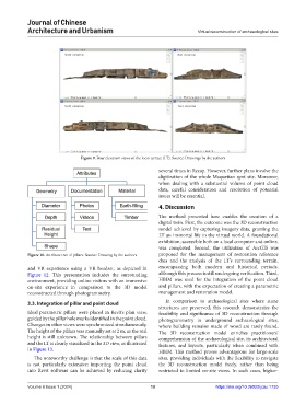
Figure 9. Four elevation views of the loess terrace (LT). Source: Drawings by the authors
several times in Recap. However, further plans involve the
digitization of the whole Maquetian spot site. Moreover,
when dealing with a substantial volume of point cloud
data, careful consideration and resolution of potential
issues will be essential.
4. Discussion
The method presented here enables the creation of a
digital twin. First, the outcome was the 3D reconstruction
model achieved by capturing imagery data, granting the
LT an immortal life in the virtual world. A foundational
exhibition, accessible both on a local computer and online,
was completed. Second, the utilization of ArcGIS was
Figure 10. Attribute tree of pillars. Source: Drawing by the authors proposed for the management of restoration reference
data and the analysis of the LT’s surrounding terrain,
and VR experience using a VR headset, as depicted in encompassing both modern and historical periods,
Figure 12. This presentation includes the surrounding although this process is still undergoing verification. Third,
environment, providing online visitors with an immersive HBIM was used for the integration of the point cloud
on-site experience in comparison to the 3D model and pillars, with the expectation of creating a parametric
reconstructed through photogrammetry. management and restoration model.
3.3. Integration of pillar and point cloud In comparison to archaeological sites where stone
structures are preserved, this research demonstrates the
Ideal parametric pillars were placed in Revit’s plan view, feasibility and significance of 3D reconstruction through
guided by the pillar hole marks identified in the point cloud. photogrammetry in underground archaeological sites,
Changes in other views were synchronized simultaneously. where building remains made of wood are rarely found.
The height of the pillars was manually set at 2 m, as the real The 3D reconstruction model enriches practitioners’
height is still unknown. The relationship between pillars comprehension of the archaeological site, its architectural
and the LT is clearly visualized in the 3D view, as illustrated features, and layouts, particularly when combined with
in Figure 13. HBIM. This method proves advantageous for large-scale
The noteworthy challenge is that the scale of this data sites, providing individuals with the flexibility to navigate
is not particularly extensive; importing the point cloud the 3D reconstruction model freely, rather than being
into Revit software can be achieved by reducing clarity restricted to limited on-site views. In such cases, higher-
Volume 6 Issue 1 (2024) 10 https://doi.org/10.36922/jcau.1735