
Page 80 - JCAU-6-1
P. 80
Journal of Chinese
Architecture and Urbanism Virtual reconstruction of archaeological sites
DJI Mavic2, allowing for direct use. behavior over time, and spatial considerations are intrinsic
(iii). The third step includes uploading these panoramic to all archeological studies. On a macro level, archaeological
photos to the 720yun website. Subsequent tasks sites from the same period are typically geographically
involve naming, categorizing, creating a sand table, dispersed, making the application of GIS essential for
and arranging hot spots. unraveling relationships among numerous sites. On a
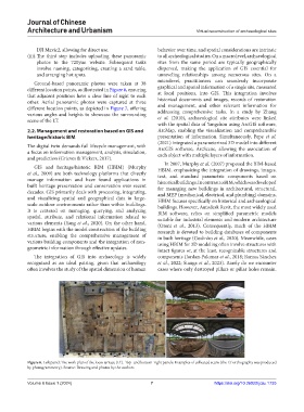
Ground-based panoramic photos were taken at 38 microlevel, practitioners can seamlessly incorporate
different location points, as illustrated in Figure 6, ensuring graphical and spatial information of a single site, measured
that adjacent positions have a clear line of sight to each at local positions, into GIS. This integration involves
other. Aerial panoramic photos were captured at three historical documents and images, records of restoration
different location points, as depicted in Figure 7, offering and management, and other relevant information for
various angles and heights to showcase the surrounding addressing comprehensive tasks. In a study by Zhang
et al. (2010), archaeological site attributes were linked
scene of the LT.
with the spatial data of Yangzhou using ArcGIS software,
2.2. Management and restoration based on GIS and ArcMap, enabling the visualization and comprehensible
heritage/historic BIM presentation of information. Simultaneously, Pepe et al.
(2021) integrated a parameterized 3D model into different
The digital twin demands full lifecycle management, with ArcGIS software, ArcScene, allowing the association of
a focus on information management, analysis, simulation, each object with multiple layers of information.
and prediction (Grieves & Vickers, 2017).
In 2007, Murphy et al. (2007) proposed the BIM-based
GIS and heritage/historic BIM (HBIM) (Murphy HBIM, emphasizing the integration of drawings, images,
et al., 2009) are both technology platforms that directly text, and standard parametric components based on
manage information and have found applications in historical buildings. In contrast to BIM, which was developed
built heritage preservation and conservation over recent for managing new buildings in architectural, structural,
decades. GIS primarily deals with processing, integrating, and MEP (mechanical, electrical, and plumbing) domains,
and visualizing spatial and geographical data in large- HBIM focuses specifically on historical and archaeological
scale outdoor environments rather than within buildings. buildings. However, Autodesk Revit, the most widely used
It is centered on managing, querying, and analyzing BIM software, relies on simplified parametric models
spatial, attribute, and relational information related to suitable for industrial elements and modern architecture
various elements (Yang et al., 2020). On the other hand, (Oreni et al., 2013). Consequently, much of the HBIM
HBIM begins with the model construction of the building research is devoted to building databases of components
structure, enabling the comprehensive management of in built heritage (Godinho et al., 2020). Meanwhile, cases
various building components and the integration of non- using HBIM for 3D modeling often involve structures with
geometric information through effective updates. intact figures or, at the least, recognizable structures and
The integration of GIS into archaeology is widely components (Jordan-Palomar et al., 2018; Ramos Sánchez
recognized as an ideal pairing, given that archaeology et al., 2022; Stanga et al., 2023). Rarely do we encounter
often involves the study of the spatial dimension of human cases where only destroyed pillars or pillar holes remain.
Figure 6. Left panel: The work plan of the loess terrace (LT). Top- and bottom-right panels: Examples of collected scans (the LT orthography was produced
by photogrammetry). Source: Drawing and photos by the authors
Volume 6 Issue 1 (2024) 7 https://doi.org/10.36922/jcau.1735