
Page 79 - JCAU-6-1
P. 79
Journal of Chinese
Architecture and Urbanism Virtual reconstruction of archaeological sites
Museum (The British Museum, 2020) and the Metropolitan capabilities. Following the established workflow – “Import
Museum of Art in New York (Diamond, 2016). Platforms Photos – Submit Aerotriangulation – Reconstruction
such as Google Arts and Culture offer an abundance of Settings – Production” – final products in formats such as.
panoramic views showcasing museums and archaeological 3mx,. 3sm,. osgb, and. obj, could be obtained.
sites. In China, plenty of museums feature virtual museum After completing aerotriangulation, a quality report
projects on their websites often spurred by incentives from was generated, revealing that 16 photos were discarded
the Chinese government.
due to the failure of strict registration of image positioning
2.1.1. A virtual reconstruction via photogrammetry information. Figure 5 illustrates photo positions and the
number of photos capturing the scene. Black dots represent
In general, archaeological remains and artifacts often the photo position, and the main part of the overlap
exhibit challenges such as blurred edges (due to the exceeds 80%, excluding the edge of the site, which did not
deterioration of the construction material and erosion contribute to the main body reconstruction. Points at the
phenomena), uneven material and color distribution, bottom of the Z-axis exhibit a distance from the dense
and difficulty in identifying corresponding points. point above, indicating photos taken by a handheld camera
Photogrammetry, when compared with laser scanning, on the ground capturing vertical walls and corners with
proves more suitable for archaeological sites, especially in intricate details. This is particularly evident in Figure 5B,
addressing complex surfaces. which depicts areas with the highest photo density where
For the acquisition of LT data, a UAV (DJI Mavic2, handheld cameras focused on capturing fine details.
DJI, China) equipped with a Hasselblad L1D-20c camera
(5472 × 3648 pixel) and a Sony α6000 digital camera with 2.1.2. An immersive experience through panoramic
24 million pixels were used. To ensure optimal conditions, photography
the data collection occurred on a cloudy day to avoid the For the acquisition of panoramic photos, an Insta360
shadows cast by the sun, as variable shading can potentially camera and a DJI Mavic2 UAV were used with the ultimate
affect the accuracy of calculation results. goal of creating a web platform that provides an immersive
The reality capture process in photogrammetry consists panorama and VR experience.
of three steps: The process involves three key steps:
• The first step involves oblique photography to obtain (i) The first step entails capturing ground-based
fundamental data using the DJI Mavic2. panoramic photos of the LT using an Insta360 camera
• The second step entails capturing images of missing and aerial panoramic photos of the surrounding site
places at a lower altitude using the DJI Mavic2. using a DJI Mavic2 UAV.
• The third step includes taking detailed pictures using (ii) In the second step, the format of ground-based
the Sony ɑ6000. panoramic photos is transformed into jpg format
To ensure the completeness and precision of the using Insta360 Studio 2023. Simultaneously, aerial
reconstruction model, the overlap rate of oblique panoramic photos are automatically generated in the
photography must meet specific requirements, usually with
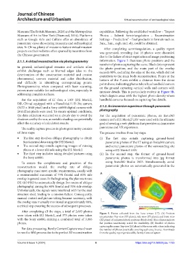
a recommended minimum of 75% frontal and 60% side A B
overlap in general cases. In the beginning, the plan was to use
DJI GO PRO to automatically design five routes of oblique
photography, aiming for 80% frontal and 70% side overlap.
Unfortunately, the signals were interfered with by the steel
structure shed, leading to a mission failure. Consequently,
manual control and picture-taking became necessary, with
the overlap rate manually monitored at approximately 80%,
a critical step ensuring the success of subsequent processes.
After completing all the steps, a total of 2,693 photos
were taken with DJI Mavic2, and 373 photos were taken Figure 5. Photos collected from the loess terrace (LT). (A) Position
uncertainties: Top view (XY plane), side view (ZY plane), and front view
with the Sony α6000, making a combined total of 3,066 (XZ plane) of computed photo positions (black dots). Blue ellipses indicate
photos. the position uncertainty, scaled for readability. (B) Number of photos
capturing the scene: Top view (XY plane) of the scene with colors indicating
For data processing, Bently ContextCapture was chosen the number of photos potentially covering each area. Source: Downloads
to run the SfM process due to its perfect 3D reconstruction from the quality report produced by Bently ContextCapture
Volume 6 Issue 1 (2024) 6 https://doi.org/10.36922/jcau.1735