
Page 26 - JCAU-7-1
P. 26
Journal of Chinese
Architecture and Urbanism Spatial syntax of temple heritage
settlement’s high overall integration and commendable was conducted between these two datasets. As shown in
spatial accessibility. Figure 6, the XY scatter plot visualizes the comprehensibility
Nestled within the surrounding mountains, the Baiyu of the axis system, with the X-axis representing global
Temple settlement’s main public edifices are strategically
positioned along its main road. This layout fosters strong
connectivity between the village and the outside world,
culminating in a high degree of overall integration and
excellent transportation accessibility. Nevertheless, the
temples located in the northern part of the settlement are
relatively distant from external transportation routes.
4.1.3. Comprehensibility
The comprehensibility of a village’s spatial structure reflects
the alignment between its overall layout and local spaces.
A higher comprehensibility signifies a spatial configuration
that is easier to understand in its entirety, whereas a lower
comprehensibility indicates the opposite.
To assess this relationship, two datasets were selected
from the Depthmap software: the global integration degree
and the local integration degree. A linear regression analysis
Figure 4. Baiyu settlement connection value and settlement status
superposition map. Source: Drawing by the author
Figure 2. Baiyu settlements satellite image. Source: Big Map (2023)
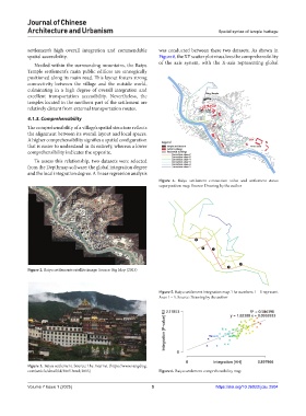
Figure 5. Baiyu settlement integration map. The numbers 1 – 5 represent
Axes 1 – 5. Source: Drawing by the author
Figure 3. Baiyu settlement. Source: The Internet (https://www.zangdiyg.
com/article/detail/id/3865.html; 2015) Figure 6. Baiyu settlement comprehensibility map
Volume 7 Issue 1 (2025) 5 https://doi.org/10.36922/jcau.2504