
Page 80 - JCAU-7-2
P. 80
Journal of Chinese
Architecture and Urbanism Spatial network analysis of hutongs
introduces innovative methods and perspectives to deepen Following the abstraction of the road system, the second
our understanding of the fundamental characteristics of phase identifies landmark roads to delineate the study
the hutong system. area. In Lynch’s (1964) seminal work, The Image of the
In addition, this study explores strategies for protecting City, landmarks are defined as distinctive and memorable
and effectively utilizing these traditional spaces amid rapid physical elements within urban landscapes, serving as aids
urbanization. Its goal is to preserve the cultural value and for urban navigation and spatial orientation. Building on this
functionality of hutong while enhancing residents’ quality framework, this study introduces the concept of “landmark
of life. By integrating quantitative and qualitative research road,” which not only facilitates traffic circulation but also
methods, this study aims to provide empirical evidence significantly influences navigation and visual perception.
to urban planners and policymakers, supporting the Landmark roads possess specific design attributes that
sustainable development and modernization of hutongs. enhance their prominence and recognizability. Typically,
2. Research methodology these roads are notably wide and aligned with major
urban axes, either east–west or north–south, making them
This study utilizes spatial network analysis methods to visually striking and easy to identify. Their design not only
examine the spatial connectivity between the hutong improves functional efficiency but also enhances the spatial
system and landmark roads using quantitative data. The legibility of the city. As Kevin Lynch highlighted, effective
research is structured into four distinct phases to achieve landmarks distinctly stand out from their surroundings.
this goal. Landmark roads, due to their widths, lengths, and
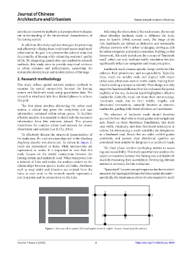
The first phase involves abstracting the urban road directional orientations, naturally function as dynamic
system, a critical step given the complexity and vast landmarks, guiding both visual attention and movement.
information contained within urban spaces. To facilitate The selection of landmark roads should therefore
effective analysis, it is essential to distill only the necessary account for their dual roles as visual guides and navigational
information from this extensive dataset. This process aids. Based on these theoretical foundations, this study
streamlines the complex urban road network for clearer uses width, continuity, and clear directional orientation as
observation and analysis (Lee & Chi, 2014). criteria for determining a road’s suitability for designation
To effectively discern the structural characteristics of as a landmark road. Roads that are wider, exhibit greater
the study area, the road structure depicted in the Qianlong continuity, and possess clear directional qualities are
Jingcheng Quantu was abstracted. As shown in Figure 1, considered most suitable for designation as landmark roads.
roads are represented as links, while intersections are The third phase involves developing metrics to assess
represented as nodes. It is important to note that this regional accessibility. This study quantitatively analyzes the
study focuses on the spatial connections between the spatial connections between the hutong area and landmark
hutong system and landmark road. When transposed into roads by evaluating their accessibility. Developing relevant
a network of links and nodes, the analysis centers on the metrics is necessary for this evaluation.
relationships between specific nodes and links. Attributes
such as road width and direction are omitted from the “Space depth” is a core concept in space syntax theory, which
links, as each node in the network merely represents a measures the topological distance between spatial elements—
junction point and its connectivity to the links. specifically, the minimum number of turns required to reach
Figure 1. Fictional urban system (left) and spatial network (right). Source: Drawing by the authors
Volume 7 Issue 2 (2025) 3 https://doi.org/10.36922/jcau.4608