
Page 128 - AJWEP-22-5
P. 128
Nkinda, et al.
a b c
d
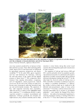
Figure 8. Pictures of (a) the Ngerengere River sub–catchment at Tangeni; (b) agricultural activities along or
near the catchment; (c) banana plantation; and (d) the Ngerengere River
Source: Photo by Nkinda R., captured in March 2025.
cover has occurred, paralleled by an increase in bare reduction in water bodies during this period raised
land and built–up areas. These shifts mirroring global concerns about prolonged dry spells and overextraction
trends, where LULCCs have been used, are influenced of water resources.
by agricultural expansion, urbanization, and climate The expansion of built-up land between 2000 and
variability. 10,12,40 In the early 2000s, sparse vegetation 2014 could be primarily driven by population growth,
and bare land dominated the landscape, reflecting especially in areas near the river catchment, as the region’s
the semi–arid nature of the region and the limited agricultural potential attracted people and accelerated
presence of dense forest. 39,40 This composition likely settlement development during that period. 28,29 On the
stemmed from ongoing deforestation, overgrazing, other hand, the observed decline in built-up areas in
and soil degradation, which progressively reduced 2024 could reflect constraints on settlement expansion,
forest cover. By the mid-2010s, changes in land cover or changes in population distribution. In addition,
65
became more pronounced, indicating intensified land this decline in built-up land can be attributed to the
use and environmental pressures. The expansion of informal and non-permanent nature of many earlier
bare land suggested worsening land degradation, settlements. 27,28 Over time, residents in these areas were
while the growth of built-up areas highlighted rapid relocated, particularly due to actions by government
urban expansion. 63,64 A simultaneous decline in sparse authorities – most notably the Pangani River Basin
vegetation pointed to continued encroachment and Authority – who enforced environmental regulations by
disturbance. Although grasslands and wetlands saw removing individuals residing or farming within 60 m
slight increases, they remained minimal, and the sharp of the river. 27,28,38 These interventions may contribute to
Volume 22 Issue 5 (2025) 122 doi: 10.36922/AJWEP025180137