
Page 120 - AJWEP-22-6
P. 120
Takele, et al.
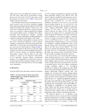
while runoff rose by an additional 9.84 mm/y (4.0%). of LULC changes on groundwater recharge in the Dire
Over the entire study period, groundwater recharge Dawa watershed, Ethiopia, from 2000 to 2022. The
decreased by 48.8 mm/y (24.5%), and surface runoff analysis indicates significant transformations in LULC,
increased by 42.8 mm/y (19.9%). Table 7 presents the where agricultural land expanded by 114.7 km (52.6%),
2
results of the change analysis. built-up areas increased by 17.8 km (79.2%),
2
These findings underscore the increasing pressure on shrublands decreased by 83.4 km (23.7%), and the
2
water resources in the Dire Dawa watershed, resulting forested regions declined by 53.6 km (62.8%). The
2
from urbanization and agricultural expansion. The SWAT hydrological modeling results demonstrate that these
model demonstrates how changes in land cover, such LULC changes substantially reduced groundwater
as the loss of shrubland and forests, disrupt the natural recharge by 48.8 mm/y (24.5%) and increased
water cycle, leading to reduced groundwater recharge surface runoff by 42.8 mm/y (19.9%). These findings
and increased surface runoff. To mitigate these effects, underscore the urgent need for sustainable land and
sustainable land management strategies, including water management strategies in the region. The SWAT
ecosystem restoration and improved urban planning, are model performance was assessed using key statistical
crucial for restoring the water balance in the region. metrics: R values of 0.84 and 0.79, NSE values of 0.75
2
The areal variation of groundwater recharge over the and 0.72, and PBIAS values of −0.1 and −11 during the
Dire Dawa watershed is significant, with the highest calibration and validation periods, respectively. Based
recharge occurring in the eastern and northwestern sub- on established evaluation benchmarks, these results
watersheds. In contrast, the central and northern regions indicate strong model performance, characterized by
have experienced a rapid decline in recharge (Figure 6). high R² and NSE values and low PBIAS. The model
47
These results underscore the need for continuous, high- effectively simulates the hydrological processes within
resolution monitoring to understand spatial and temporal the study area and is well-suited for projecting river
effects of land-use changes on watershed hydrology. discharge and assessing future hydrological changes
Maintaining a balance between land use and water driven by land-use changes and climate variations.
resources is critical for the long-term sustainability The study by Jin et al., in the Jing River basin in
50
of the watershed. Through adaptive management China, demonstrated that LULC changes significantly
strategies, the sustainability of groundwater resources reduced runoff and altered hydrological cycle processes.
can be ensured, and the ecological integrity of the area, These findings align with those of the present study,
as well as the way of life that relies on its water supply, confirming that urbanization and deforestation contribute
can be maintained. to increased surface runoff and reduced groundwater
recharge. Similarly, Lindle et al. investigated
51
4. Discussion groundwater recharge in the Limpopo province, South
Africa, and revealed that ephemeral river flow and LULC
Using the SWAT model, this study examined the impacts changes significantly influence recharge rates. This
supports the conclusion that land-use changes disrupt
Table 7. Average annual recharge and surface natural recharge mechanisms, highlighting the need for
runoff changes due to land use and land cover improved water resource management. In another related
changes (2022–2000) study, Mechal et al. analyzed groundwater recharge in
13
Year Simulated values the Ziway Lake watershed of the Ethiopian Rift using
Groundwater Surface runoff the SWAT model and concluded that recharge rates vary
recharge significantly due to topographic and climatic influences.
mm/y % mm/y % This finding is comparable to the present study’s
results, which show that climate variability and terrain
2000 199.4 39.2 215.2 29.8 characteristics play pivotal roles in recharge patterns.
2010 158.9 31.2 248.1 34.4 Collectively, these studies reinforce the importance of
2022 150.7 29.6 258.0 35.8 integrating climate variability into land-use planning.
25
Changes The study by Bucha et al. in Ethiopia’s Lake
2010−2000 −40.6 −20.4 32.9 15.3 Chamo sub-basin observed increased surface runoff and
2022−2010 −8.2 −5.2 9.8 4.0 decreased infiltration due to land-use changes, aligning
with the present study’s conclusions. Additional studies
2022−2000 −48.8 −24.5 42.8 19.9 support these findings. For example, a study of the
Volume 22 Issue 6 (2025) 114 doi: 10.36922/AJWEP025180139