
Page 121 - AJWEP-22-6
P. 121
SWAT-based LULC impacts on groundwater recharge
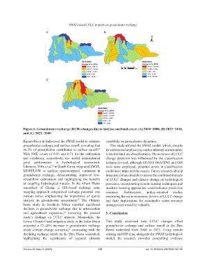
A B
C
Figure 6. Groundwater recharge (RCH) changes due to land use and land cover: (A) 2010−2000, (B) 2022−2010,
and (C) 2022−2000
Kanari River in India used the SWAT model to estimate variability on groundwater dynamics.
groundwater recharge and surface runoff, revealing that This study utilized the SWAT model, which, despite
46.2% of precipitation contributed to surface runoff. its widespread application, carries inherent uncertainties
20
With NSE values of 0.83 and 0.71 for the calibration related to land-use classifications. The accuracy of LULC
and validation, respectively, the model demonstrated change detection was influenced by the classification
good performance in hydrological assessment. techniques used; although ERDAS IMAGINE and GIS
Likewise, Yifru et al. in South Korea integrated SWAT- tools were employed, potential errors in classification
18
MODFLOW to analyze spatiotemporal variations in could have impacted the results. Future research should
groundwater recharge, demonstrating improved low- integrate climate models to assess the combined impacts
streamflow estimations and highlighting the benefits of LULC changes and climate change on hydrological
of coupling hydrological models. In the Afram Plains processes. Incorporating remote sensing techniques and
watershed of Ghana, a GIS-based recharge zone machine learning approaches could enhance prediction
mapping approach categorized recharge potential into accuracy. Furthermore, policy-oriented studies
various zones, emphasizing the importance of spatial examining the socio-economic drivers of LULC change
analysis in groundwater assessment. The Olifants and their implications for sustainable water resource
52
basin study in Southern Africa reported significant management would be valuable.
declines in groundwater recharge due to urbanization
and agricultural expansion, mirroring the present 5. Conclusion
14
study’s findings on LULC impacts. Meanwhile, the
Lower Chenab Canal irrigation study in the Indus Basin This study examined how LULC changes affect
projected a 37–40% increase in groundwater recharge groundwater recharge and surface runoff in the Dire
under climate change scenarios, contrasting with the Dawa watershed from 2000 to 2022. Using remote
53
declining recharge trends in the Dire Dawa watershed, sensing and GIS data, alongside the SWAT hydrological
highlighting the significance of regional climatic model, the research provides compelling evidence
Volume 22 Issue 6 (2025) 115 doi: 10.36922/AJWEP025180139