
Page 177 - AJWEP-v22i2
P. 177
Topographic and watershed analysis
Modeling System), and cross-referencing with
topographic maps. These procedures demonstrated that
ArcGIS Pro is the most suitable option for this study as
it produces reliable and accurate hydrological outputs.
3.3. Methods
3.3.1. Sentinel-1 and -2 images pre-processing
The Sentinel-1 images were pre-processed using
the Sentinel Application Platform (SNAP) software
(version 11.0.0). The data can be utilized for generating
DEMs through a series of pre-processing steps,
including radiometric calibration to convert raw digital
data into backscatter coefficients that reflect the physical
Figure 1. The study area (Haditha Lake) 28,29 properties of the surface, thermal noise removal to
reduce or eliminate noise from the satellite’s electronics,
which can affect data quality, and terrain correction to
correct distortions caused by terrain (such as mountains
or valleys) that affect the angle of incidence of radar
waves, as shown in Figure 3.
32
The DEM was then used to conduct the topographic
and watershed hydrologic analyses. The Sentinel-2
images were pre-processed using SNAP software,
geometrically corrected to ensure accurate locations,
and then rescaled to 10 m resolution to improve analysis
and reduce unnecessary data. Spectral bands (2, 3, 4,
and 8) are selected for vegetation studies, and the data
are exported to GeoTiff format for LULC classification,
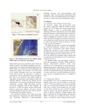
Figure 2. The Sentinel-1A (S1A_IW_GRDH) image as shown in Figure 4.
of the study area. Scale bar: (0.11 miles) To manage satellite data uncertainties, Sentinel-1
SAR data guaranteed all-weather DEM production,
interferometry processing of Sentinel-1 data. Due to its whereas cloud-masked Sentinel-2 photos were
synthetic aperture radar (SAR) capabilities, Sentinel-1 utilized for LULC classification to reduce uncertainty.
is particularly well-suited for producing high-resolution Radiometric/geometric adjustments in SNAP software
DEMs, which are essential for precise topographic and decreased distortions, whereas interferometric methods
hydrological analysis. The Sentinel-1 can collect data (in SAR) increased terrain accuracy. Despite atmospheric
in all weather, including cloud cover and sunshine, or sensor restrictions, consistent hydrological analysis
unlike optical sensors like Sentinel-2 or Landsat 8, was ensured by resampling the data to a resolution of
guaranteeing constant, dependable imagery throughout 10 m.
time. This is very useful for areas where weather or
atmospheric circumstances could ordinarily make data 3.3.2. Topographic analysis
collecting difficult. ArcGIS Pro was selected for this GIS techniques were used to analyze the terrain and
study because of its advanced hydrological modeling identify erosion areas in the river basin, as in previous
capabilities, excellent DEM processing accuracy, studies. 33,34 The slope, direction, curvature, and shading
and smooth integration with RS data (Sentinel-1 & maps were created using ArcGIS Pro tools. These tools
Sentinel-2). ArcGIS Pro offers stronger spatial tools, were used to analyze terrain features and their effect
improved raster-based analysis, and more accurate on water flow. Contour lines were created to visualize
watershed delineation than Quantum GIS and System elevation changes and identify potential water flow
for Automated Geoscientific Analyses. paths, as shown in Figure 5. Terrain analysis tools
The hydrological findings were verified using field play an important role in understanding and analyzing
data verification, comparisons with other GIS models DEMs. The slope tool calculates the degree of slope,
(e.g., Hydrologic Engineering Center–Hydrologic which is essential for erosion, drainage, and structural
Volume 22 Issue 2 (2025) 171 doi: 10.36922/ajwep.8499