
Page 75 - AJWEP-v22i2
P. 75
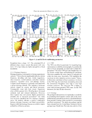
Flood risk assessment of Barak river valley

                A                                                  B


                                           Figure 3. (A and B) Flood conditioning parameters

                floodplains have a slope <10°. The calculated FR of   4.1.5. TWI
                different  slope  classes  reveals  that  pixels  with  very   The TWI is an effective parameter for measuring long-
                low (<10°) slope values are highly susceptible to flood   term moisture availability in topography. It quantifies the
                inundation.                                         effect of local topography on runoff and overland flow
                                                                    generation.  The area’s TWI provides insights into two
                                                                              35
                4.1.4. Drainage frequency                           key factors: terrain shape and hydrological conditions.
                Drainage frequency is the number of stream segments per   This index quantifies the water content of each grid cell
                unit area.  Various factors significantly influence stream   within the study area. Essentially, TWI highlights the
                        32
                frequency,  including  rock  type,  terrain  ruggedness,   variations in water saturation across a region.  Hence,
                                                                                                             33
                slope steepness, rainfall  patterns,  subsurface material   it effectively contributes to flood occurrence. As shown
                properties, vegetation  cover, and drainage density.   in the TWI map, the water body surrounding areas and
                A higher stream frequency is generally associated with   the  downstream  floodplains  have  high  to  very  high
                a denser drainage network. This indicates a landscape   moisture  saturation.  The  class-wise  FR  is  higher  in
                actively  shaped  by  erosion  and  fluvial  processes.   areas with moisture-saturated TWI zones. As the TWI
                Consequently,  areas  with  high  stream  frequencies   decreases, the class FR also decreases.
                often exhibit a greater risk of flooding due to increased
                sediment  load  and  reduced  infiltration.  However,   4.1.6. Geology
                these  regions  may  also  possess higher  groundwater   The geological characteristics of a region play a crucial role
                potential  due to  increased  percolation.  The  study   in determining flood hazards. Factors such as the rocks’
                                                    34
                area  has  been  classified  into  five  drainage  frequency   infiltration and permeability are closely related and influence
                zones.  FR  analysis  indicates  a  positive  relationship   flood potential. Geology is also essential for reconstructing
                between  drainage  frequency  and  flood  susceptibility.   past flood occurrences.  The study area geology map has
                                                                                        4
                Regions with high drainage frequencies exhibit a higher   been extracted from the United States Geological Survey
                probability of flood occurrence.                    geology map of South Asia. The study area consists of four


                Volume 22 Issue 2 (2025)                        69                           doi: 10.36922/AJWEP025040019