
Page 88 - AJWEP-v22i2
P. 88
Ghosh and Prakasam
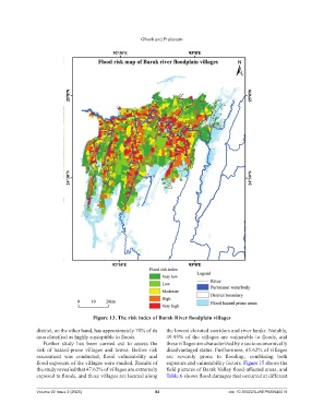
Figure 13. The risk index of Barak River floodplain villages
district, on the other hand, has approximately 70% of its the lowest elevated corridors and river banks. Notably,
area classified as highly susceptible to floods. 49.95% of the villages are vulnerable to floods, and
Further study has been carried out to assess the these villages are characterized by a socio-economically
risk of hazard-prone villages and towns. Before risk disadvantaged status. Furthermore, 45.62% of villages
assessment was conducted, flood vulnerability and are severely prone to flooding, combining both
flood exposure of the villages were studied. Results of exposure and vulnerability factors. Figure 15 shows the
the study revealed that 47.62% of villages are extremely field pictures of Barak Valley flood-affected areas, and
exposed to floods, and these villages are located along Table 6 shows flood damages that occurred at different
Volume 22 Issue 2 (2025) 82 doi: 10.36922/AJWEP025040019