
Page 85 - AJWEP-v22i2
P. 85
Flood risk assessment of Barak river valley
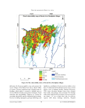
Figure 10. The vulnerability index of Barak River floodplain villages
delineates the flood-susceptible areas and assesses the landforms, contribute to flood occurrence within a river
risk to villages of the Barak River basin. Barak Valley basin. To delineate the flood hazard-prone areas, several
of Assam is densely populated and is highly prone to factors, such as drainage density, drainage frequency,
flooding, which makes it essential to identify areas at TWI, slope, elevation, distance from rivers, distance
risk for effective disaster management strategies. Flood from roads, and geology, were analyzed. The findings
modeling and susceptibility mapping are crucial for of the study indicate that areas below 250 m in elevation
assessing vulnerability and developing mitigation plans. and slopes <10° are at high flood risk. In addition,
Factors, including topography, geology, hydrology, and regions with dense drainage networks, frequent
Volume 22 Issue 2 (2025) 79 doi: 10.36922/AJWEP025040019