
Page 82 - AJWEP-v22i2
P. 82
Ghosh and Prakasam
of river floodplains. Flood vulnerability of certain
39
regions is a function of exposure to flood susceptibility,
adaptive capacity, and elements at risk. 40,41 In the
present context, six variables – population density,
household density, child population, illiteracy rate,
marginal worker, and agricultural worker – were
considered at the village level based on the 2011
Census of India. Weights were assigned depending
on the level of significance (Table 4). The spatial
distribution of vulnerability indicators is represented
in Figure 9. The highest weights were assigned to the
villages with high household density, high population
density, high illiteracy rate, and a high number of
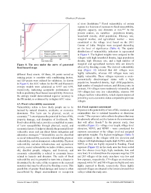
Figure 8. The area under the curve of generated marginal and agricultural workers who are directly
flood hazard maps affected by flooding events. The derived vulnerability
map (Figure 10) inferred that 461 villages were
different flood events. Of these, 80 points served as highly vulnerable, whereas 485 villages were very
training points to correlate with conditioning factors, highly vulnerable. These villages represent a socio-
and 120 points were utilized for validation. As shown economically disadvantaged status with a high
in Figure 8, the AUC values for the FR and Shannon’s population, household density, high child population,
entropy models were calculated as 0.957 and 0.99, high number of marginal workers, and illiteracy rate. In
respectively, indicating acceptable performance for contrast, 330 villages were moderately vulnerable, and
both in predicting flood hazard susceptibility. However, 310 villages had very low vulnerability, whereas 308
the entropy model demonstrated superior accuracy to villages had low vulnerability, which depicts improved
the FR model, as evidenced by its higher AUC value. prevailing socio-economic status compared to previous
villages.
4.3. Flood vulnerability assessment
Vulnerability refers to how likely people are to be 4.4. Flood exposure assessment
harmed by natural disasters, accidents, or economic Exposure is the potentiality of loss of life, resources, and
downturns. This harm can be physical, social, or commodities due to external hazardous or disastrous
economic. It encompasses the potential for loss of life, events. The exposure index reflects the places that may
37
37
property damage, and disruption of livelihoods. The be adversely affected and the factors in the environment
flood vulnerability index provides a simplified measure that will affect floods. In the present study, four
42
of harm susceptibility through physical, social, and variables (Figure 11) – village-river length, village-level
economic factors. It helps to identify the potential flood- elevation, NDVI, and NDWI – were considered for
vulnerable areas and can direct future mitigation and exposure assessment at the village level and assigned
adaptation strategies. Vulnerability can be classified appropriate weights. The highest weightages (Table 5)
38
as social vulnerability, economic vulnerability, physical were assigned to the villages with low elevation and
vulnerability, and environmental vulnerability. Physical villages with high drainage length, high NDWI, and low
vulnerability includes infrastructure and agricultural NDVI, as they are highly exposed to flooding. Flood
activity; social vulnerability includes children, women, exposure (Figure 12) in the study area has been scaled
old, disabled people, refugees, and livestock; and into five classes (very high, high, moderate, low, and
economic vulnerability is related to economic losses very low). It is inferred from the exposure map that 530
related to hazards and disasters. The scale of flood and 283 villages of the study area have very low and
vulnerability and its potential to turn into a disaster is low exposure, respectively; 179 villages are moderately
determined by the value of the receptors or the exposed exposed, while 561 and 340 villages are highly and very
materials that may be affected by flooding events. This highly exposed to floods, respectively. These highly
possibility of greater flood damage and losses is often exposed villages are situated in the lowest elevated river
exacerbated by illegal encroachment or occupation valleys within the study area.
Volume 22 Issue 2 (2025) 76 doi: 10.36922/AJWEP025040019