
Page 87 - AJWEP-v22i2
P. 87
Flood risk assessment of Barak river valley
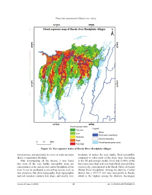
Figure 12. The exposure index of Barak River floodplain villages
watercourses, and proximity to rivers or roads are more locations. It makes the area highly flood-susceptible
likely to experience flooding. compared to other parts of the study area. According
After investigating all the factors, it was found to the FR and entropy model, 18.62 and 21.48% of the
that most of the very highly susceptible areas are basin area have high and very high flood susceptibility,
concentrated in the eastern and central floodplain of the respectively, concentrated in the Barak Valley of Assam
river. It can be attributed to prevailing factors, such as (Barak River floodplain). Among the districts, Cachar
low elevation, flat plain topography, high topographic district has a 1973.37 km² area susceptible to floods,
and soil moisture content, low slope, and nearby river which is the highest among the districts. Karimganj
Volume 22 Issue 2 (2025) 81 doi: 10.36922/AJWEP025040019