
Page 141 - AJWEP-v22i3
P. 141
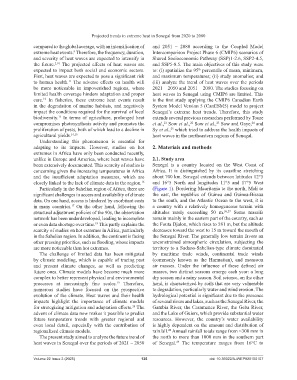
Projected trends in extreme heat in Senegal from 2020 to 2080

                compared to the global average, with an intensification of   and  2051 – 2080 according  to  the  Coupled  Model
                extreme heat events.  Therefore, the frequency, duration,   Intercomparison Project Phase 6 (CMIP6) scenarios of
                                 9
                and severity of heat waves are expected to intensify in   Shared Socioeconomic Pathway (SSP)1-2.6, SSP2-4.5,
                the  future. 2,10  The  projected  effects  of  heat  waves  are   and SSP5-8.5. The main objectives of this study were
                expected to impact both social and economic sectors.   to: (i) spatialize the 95  percentile of mean, minimum,
                                                                                        th
                First, heat waves are expected to pose a significant risk   and maximum temperatures; (ii) study anomalies; and
                to human health.  The  adverse  effects  on  health  will   (iii) analyze the trend of heat waves over the periods
                               11
                be more noticeable  in impoverished regions, where   2021 – 2050 and 2051 – 2080. The studies focusing on
                limited health coverage hinders adaptation and proper   heat waves in Senegal using CMIP6 are limited. This
                care.   In  fisheries,  these  extreme  heat  events  result   is the first study applying the CMIP6 Canadian Earth
                    12
                in the degradation of marine habitats, and negatively   System Model Version 5 (CanESM5) model to project
                impact the conditions required for the survival of local   Senegal’s extreme  heat  trends.  Therefore,  this  study
                biodiversity.  In terms of agriculture,  prolonged heat   extends several previous researches performed by Toure
                           13
                compromises photosynthesis activity and promotes the   et al.,  Sow et al.,  Sow et al.,  Sow and Gaye,  and
                                                                         21
                                                                                     22
                                                                                                23
                                                                                                                24
                proliferation of pests, both of which lead to a decline in   Sy et al.,  which tried to address the health impacts of
                                                                            25
                agricultural yields. 14,15                          heat waves in the northeastern regions of Senegal.
                  Understanding this phenomenon  is essential  for
                adapting to its impacts. However, studies on hot    2. Materials and methods
                extremes in Africa have only been conducted recently,
                unlike in Europe and America, where heat waves have   2.1. Study area
                been extensively documented. This scarcity of studies is   Senegal is a country located on the  West Coast of
                concerning given the increasing temperatures in Africa   Africa. It is distinguished by its coastline  stretching
                and  the  insufficient  adaptation  measures,  which  are   about 700 km. Senegal extends between latitudes 12°5
                closely linked to the lack of climate data in the region. 16  and  16°5  North  and  longitudes  11°5  and  17°5  West
                  Particularly in the Sahelian region of Africa, there are   (Figure 1). Bordering Mauritania to the north, Mali to
                significant challenges in access and availability of climate   the east,  the republics  of Guinea  and Guinea-Bissau
                data. On one hand, access is hindered by exorbitant costs   to the south, and the Atlantic Ocean to the west, it is
                in many countries.  On the other hand, following the   a country with a relatively homogeneous terrain with
                                17
                structural adjustment policies of the 90s, the observation   altitudes  rarely exceeding  50  m. 26,27  Some massifs
                network has been underdeveloped, leading to incomplete   remain mainly in the eastern part of the country, such as
                or even data shortage over time.  This partly explains the   the Fouta Djalon, which rises to 581 m, but the altitude
                                           18
                scarcity of studies on hot extremes in Africa, particularly   decreases toward the west to 15 m toward the mouth of
                in the Sahelian region. In addition, the continent is facing   the Senegal River. The generally low terrain favors an
                other pressing priorities, such as flooding, whose impacts   unconstrained  atmospheric  circulation,  subjecting  the
                are more noticeable than hot extremes.              territory to a Sudano-Sahelian-type climate dominated
                  The  challenge of limited  data  has been  mitigated   by maritime  trade winds, continental  trade winds
                by climate modeling, which is capable of tracing past   (commonly known as the Harmattan),  and monsoon
                and present climate  changes, as well as predicting   air  masses.  Under  the  influence  of  these  defined  air
                future ones. Climate models have become much more   masses, two distinct seasons emerge each year: a long
                complex to better represent physical and environmental   dry season and a rainy season. Soil science, on the other
                processes  at  increasingly  fine  scales.  Therefore,   hand, is characterized by soils that are very vulnerable
                                                    19
                numerous studies have focused on the prospective    to degradation, particularly water and wind erosion. The
                evolution of the climate. Heat waves and their health   hydrological potential is significant due to the presence
                impacts  highlight  the  importance  of climate  models   of several rivers and lakes, such as the Senegal River, the
                for strategizing mitigation and adaptation efforts.  The   Gambia River, the Casamance River, the Geba River,
                                                           20
                advent of climate data now makes it possible to predict   and the Lake of Guiers, which provide substantial water
                future  temperature  trends  with  greater  regional  and   resources.  However,  the  country’s water  availability
                even local  detail,  especially with the contribution  of   is highly dependent on the amount and distribution of
                regionalized climate models.                        rainfall.  Annual rainfall totals range from <300 mm in
                                                                           28
                  The present study aimed to analyze the future trend of   the north to more than 1000 mm in the southern part
                heat waves in Senegal over the periods of 2021 – 2050   of  Senegal.   The  temperature  ranges  from  16°C  to
                                                                               29


                Volume 22 Issue 3 (2025)                       135                           doi: 10.36922/AJWEP025150107