
Page 153 - AJWEP-v22i3
P. 153
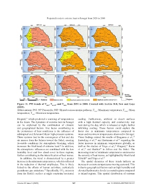
Projected trends in extreme heat in Senegal from 2020 to 2080


                Figure 11. P95 trends of T , T mean , and T max  from 2051 to 2080. Created with ArcGis 10.8, Sow and Gaye
                                         min
                (2025).
                Abbreviations: P95: 95  Percentile; SSP: Shared socioeconomic pathway; T max : Maximum temperature; T mean : Mean
                                    th
                temperature; T : Minimum temperature.
                             min
                Ringard,  which predicted a warming of temperatures   cooling.  Furthermore,  artificial  or  desert  surfaces
                       57
                in the future. The dynamics of extreme heat in Senegal   with a high thermal capacity  and conductivity  trap
                can be explained  by the combination  of climatic   heat during the day, which is released at night, further
                and geographical  factors. One factor contributing  to   inhibiting  cooling.  These  factors  could  explain  the
                the  persistence  of  heat  conditions  is  the  influence  of   faster rise in minimum  temperatures  compared to
                subtropical and Saharan-Libyan high-pressure systems.   mean and maximum temperatures observed in Senegal.
                These systems lead to the convergence of hot and dry   These findings extend the results of Braganza et al.,
                                                                                                                    59
                air masses from the Sahara toward the Sahel, creating   Easterling et al.,  and Hartmann et al.  regarding the
                                                                                                       61
                                                                                   60
                favorable conditions for atmospheric blocking, which   faster  increase  in minimum  temperatures  globally, as
                increases the likelihood of extreme heat.  In addition,   well as the studies of Trigo et al.,  Ringard,  Rome
                                                                                                    62
                                                                                                              57
                                                    22
                the atmospheric influences are combined with the low   et  al.,   and  Barbier   in  Africa  and  the  Sahel.  The
                                                                                       64
                                                                          63
                humidity level and low cloud cover in these regions,   increasing trend of minimum temperatures underscores
                further contributing to the intensification of heat waves.  the severity of heat waves, as highlighted by Meehl and
                  In addition, the trend is characterized by a greater   Tebaldi  and Trigo et al. 62
                                                                           65
                increase in the minimum temperatures, which is reflected   The spatial dynamics of these trends indicate  an
                in the reduction of thermal amplitudes. This is likely   increase in extreme temperatures moving eastward. This
                linked  to  the  effects  of  human  activities,  particularly   is due to geographical factors such as high humidity and
                greenhouse gas emissions.  Specifically, CO  emission   elevated hydrometric levels in coastal regions compared
                                       58
                                                        2
                from the Earth’s surface at night constrains nocturnal   to inland regions. This spatial distribution of extreme
                Volume 22 Issue 3 (2025)                       147                           doi: 10.36922/AJWEP025150107