
Page 96 - EER-2-2
P. 96
Explora: Environment
and Resource Assessing ecosystems by land cover and landscapes
A
B C
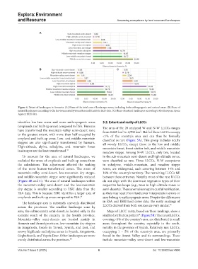
Figure 4. Extent of landscapes in Armenia. (A) Share of the total area of landscape zones, including both anthropogenic and natural areas. (B) Share of
natural landscapes according to the Environmental Systems Research Institute 2023 data. (C) Share of natural landscapes according to the European Space
Agency 2021 data.
identifies less tree cover and more anthropogenic areas 3.2. Extent and rarity of LLCCs
(croplands and built-up areas) compared to ESA. Humans The area of the 20 analyzed W and N-W LLCCs ranges
have transformed the mountain-valley semi-desert zone from 0.005 km to 4,700 km . Half of these LLCCs occupy
2
2
to the greatest extent, with more than half occupied by <1% of the country’s area and can thus be formally
cropland and built-up areas. Low- and middle-mountain classified as rare (Figure 5A). This group includes nearly
steppes are also significantly transformed by humans. all woody LLCCs, except those in the low and middle
High-altitude, alpine, subalpine, and mountain forest mountain forest, forest shelter belt, and middle mountain
landscapes are the least transformed. 44 meadow steppe. Among N-W LLCCs, only two, located
To account for the area of natural landscapes, we in the sub-mountain semi-desert and high-altitude zones,
excluded the areas of croplands and built-up zones from were classified as rare. Three LLCCs, N-W ecosystems
the calculations. This adjustment affected the ranking in subalpine, middle-mountain, and meadow steppe
of the most human-transformed zones. The areas of zones, are widespread, each covering between 14% and
mountain-valley semi-desert, low-mountain dry steppe, 16% of the country’s territory. The remaining LLCCs fall
and middle-mountain steppe were significantly reduced between these extremes. Notably, most of the rare LLCCs
(Figure 4B and C). The area of natural landscapes within do not align with the dominant vegetation types of their
the mountain-valley semi-desert and the low-mountain respective landscape (e.g., trees in high-altitude zones or
dry steppe is smaller according to ESRI data than the semi-deserts). These anomalies require careful verification,
ESA data. This is because ESRI identifies a larger area of as they may result from land cover interpretation errors or
croplands and built-up areas compared to ESA. 44 may belong to anthropogenic areas. Despite the differences
The landscape area is extremely unevenly distributed in ESA and ESRI land cover data, the rarity rankings of
across the provinces. The smallest landscape zone by LLCCs derived from both sources are very similar. 45
area, the submountain semi-desert, is located only in the Maps of LLCC rarity, based on these rankings, show a
extreme south of the country, in the Syunik province. similar distribution pattern (Figure 5B). The rarest LLCCs,
45
Mountain-valley semi-deserts are located mainly in covering <1% of the country’s area, are distributed in small
Armavir and Ararat provinces, low-mountain dry steppes areas throughout the country, especially in the south,
in Aragatsotn, forests in Tavush, Syunik, and Lori, and notably in the province of Syunik. Relatively rare LLCCs,
snowy highlands and alpine zones in Syunik, Aragatsotn, occupying 1 – 5% of the country’s area, are primarily
Gegharkunik, and Vayots Dzor. Other landscapes are more found in the Ararat Valley and its surroundings. These
evenly distributed across the provinces. 44 include mountain-valley semi-desert and low-mountain
Volume 2 Issue 2 (2025) 6 doi: 10.36922/eer.4996