
Page 97 - EER-2-2
P. 97
Explora: Environment
and Resource Assessing ecosystems by land cover and landscapes
A B
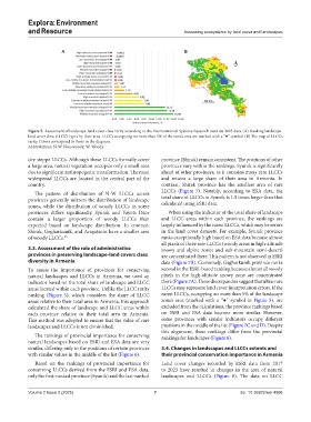
Figure 5. Assessment of landscape-land cover class rarity according to the Environmental Systems Research Institute 2023 data. (A) Ranking landscape-
land cover class (LLCC) types by their area. LLCCs occupying no more than 5% of the zone’s area are marked with a “●” symbol. (B) The map of LLCCs
rarity. Colors correspond to those in the diagram.
Abbreviations: N-W: Non-woody; W: Woody.
dry steppe LLCCs. Although these LLCCs formally cover province (Shirak) remain consistent. The positions of other
a large area, natural vegetation occupies only a small area provinces vary within the rankings. Syunik is significantly
due to significant anthropogenic transformation. The most ahead of other provinces, as it contains many rare LLCCs
widespread LLCCs are located in the central part of the and retains a large share of their area in Armenia. In
country. contrast, Shirak province has the smallest area of rare
The pattern of distribution of N-W LLCCs across LLCCs (Figure 7). Notably, according to ESA data, the
provinces generally mirrors the distribution of landscape total share of LLCCs in Syunik is 1.5 times larger than that
zones, while the distribution of woody LLCCs in some calculated using ESRI data.
provinces differs significantly. Syunik and Vayots Dzor When using the indicator of the total share of landscape
contain a larger proportion of woody LLCCs than and LLCC areas within each province, the rankings are
expected based on landscape distribution. In contrast, largely influenced by the rarest LLCCs, which may be errors
Shirak, Gegharkunik, and Aragatsotn have a smaller area in the land cover datasets. For example, Syunik province
of woody LLCCs. 45 ranks exceptionally high based on ESA data because almost
all pixels of three rare LLCCs (woody areas in high-altitude
3.3. Assessment of the role of administrative snowy and alpine zones and sub-mountain semi-desert)
provinces in preserving landscape-land covers class are concentrated there. This pattern is not observed in ESRI
diversity in Armenia data (Figure 7B). Conversely, Gegharkunik province ranks
To assess the importance of provinces for conserving second in the ESRI-based ranking because almost all woody
natural landscapes and LLCCs in Armenia, we used an pixels in the high-altitude snowy zone are concentrated
indicator based on the total share of landscape and LLCC there (Figure 7A). These discrepancies suggest that ultra-rare
areas located within each province. Unlike the LLCC rarity LLCCs may represent land cover interpretation errors. If the
ranking (Figure 5), which considers the share of LLCC rarest LLCCs, occupying no more than 5% of the landscape
areas relative to their total area in Armenia, this approach zone’s area (marked with a “●” symbol in Figure 5), are
calculated the share of landscape and LLCC areas within excluded from the calculations, the province rankings based
each province relative to their total area in Armenia. on ESRI and ESA data become more similar. However,
This method was adopted to ensure that the value of rare some provinces with similar indicators occupy different
landscapes and LLCCs is not diminished. positions in the middle of the list (Figure 7C and D). Despite
this alignment, these rankings differ from the provincial
The rankings of provincial importance for conserving rankings for landscapes (Figure 6).
natural landscapes based on ESRI and ESA data are very
similar, differing only in the positions of certain provinces 3.4. Changes in landscapes and LLCCs extents and
with similar values in the middle of the list (Figure 6). their provincial conservation importance in Armenia
Based on the rankings of provincial importance for Land cover changes recorded by ESRI data from 2017
conserving LLCCs derived from the ESRI and ESA data, to 2023 have resulted in changes in the area of natural
only the first-ranked province (Syunik) and the last-ranked landscapes and LLCCs (Figure 8). The data on LLCC
Volume 2 Issue 2 (2025) 7 doi: 10.36922/eer.4996