
Page 121 - JCAU-7-3
P. 121
Journal of Chinese
Architecture and Urbanism Spatial analysis of urban garden space
affordable, fresh food for vulnerable communities. vegetation index (NDVI) maps (Figure 4) were generated
The conversion of agricultural land into residential using Google Earth Engine, and the stratified random
and commercial developments not only worsens food sampling method was applied to extract NDVI pixels for
inequality but also undermines urban food supply 5 time-series images. The extracted data were classified into
sustainability (Esfandiar & Fadaei, 2022; Soltani & six vegetation classes, and sample points were harvested
Sharifi, 2022). for classification using machine learning algorithms in
The City of Zanjan, located on the Tehran–Tabriz route, R software. Image classification was performed using
is one of the major urban centers in eastern Zanjan province, random forest (RF) methods and the deep learning neural
Iran. It sits at an average elevation of 1,640 m above sea network (NNET). The classified images from the 5 time-
level (Molaei Yeganeh, 2019). With a population exceeding series datasets were then imported into IDRISI SELVA
430,000 and a land area of 6,500 ha, Zanjan City serves as software to analyze land cover changes in the study area.
the provincial capital (Daviran, 2023). Due to its climate This software was used to extract and assess all types of
and geographical conditions, the areas surrounding Zanjan land cover changes based on the classified images.
are primarily dedicated to agricultural and horticultural RF is a powerful machine learning algorithm for land
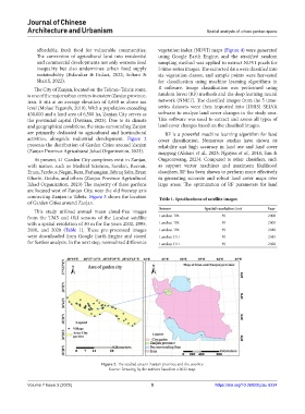
activities, alongside industrial development. Figure 2 cover classification. Numerous studies have shown its
presents the distribution of Garden Cities around Zanjan reliability and high accuracy in land use and land cover
(Zanjan Province Agricultural Jahad Organization, 2023). mapping (Alshari et al., 2023; Nguyen et al., 2018; Sun &
At present, 41 Garden City complexes exist in Zanjan, Ongsomwang, 2023). Compared to other classifiers, such
with names, such as Medical Sciences, Savalan, Rezvan, as support vector machines and maximum likelihood
Eram, Ferdous, Negin, Reza, Farhangian, Ishraq Sabz, Eram classifiers, RF has been shown to perform more effectively
Gharbi, Geisha, and others (Zanjan Province Agricultural in generating accurate and robust land cover maps over
Jahad Organization, 2023) The majority of these gardens large areas. The optimization of RF parameters for land
are located west of Zanjan City, near the old freeway axis
connecting Zanjan to Tabriz. Figure 3 shows the location Table 1. Specifications of satellite images
of Garden Cities around Zanjan.
Sensor Spatial resolution (m) Year
This study utilized annual mean cloud-free images
from the TM5 and OLI sensors of the Landsat satellite Landsat TM 30 2000
with a spatial resolution of 30 m for the years 2000, 2005, Landsat TM 30 2005
2010, and 2020 (Table 1). These pre-processed images Landsat TM 30 2010
were downloaded from Google Earth Engine and stored Landsat OLI 30 2015
for further analysis. In the next step, normalized difference Landsat OLI 30 2020
Figure 2. The studied area in Zanjan province and the country
Source: Drawing by the authors based on a 2022 map.
Volume 7 Issue 3 (2025) 5 https://doi.org/10.36922/jcau.6234