
Page 127 - JCAU-7-3
P. 127
Journal of Chinese
Architecture and Urbanism Spatial analysis of urban garden space
A B
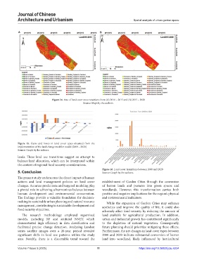
Figure 14. Rate of land cover area transitions from (A) 2010 – 2015 and (B) 2015 – 2020
Source: Maps by the authors.
Figure 15. Gains and losses in land cover types obtained from the
implementation of the land change modeler model (2000 – 2020)
Source: Graph by the authors.
lands. These land use transitions suggest an attempt to
balance land allocation, which can be interpreted within
the context of regional food security considerations.
Figure 16. Land cover transitions between 2000 and 2020
5. Conclusion Source: Graph by the authors.
The present study underscores the direct impact of human
actions and land management policies on land cover establishment of Garden Cities through the conversion
changes. Accurate predictions and targeted modeling play of barren lands and pastures into green spaces and
a pivotal role in achieving a harmonious balance between woodlands. However, this transformation carries both
human development and environmental conservation. positive and negative implications for the region’s physical
The findings provide a valuable foundation for decision- and environmental indicators.
making in sustainable urban planning and natural resource While the expansion of Garden Cities may enhance
management, contributing to sustainable development and aesthetics and improve the quality of life, it could also
food security objectives. adversely affect food security by reducing the amount of
The research methodology employed supervised land available for agricultural production. In addition,
models, including RF and artificial NNET, which urban and industrial growth has contributed significantly
demonstrated high efficiency in data classification and to the depletion of natural vegetation. Consequently,
facilitated precise change detection. Analyzing Landsat future planning should prioritize mitigating these effects.
series satellite images over a 20-year period revealed Furthermore, the net changes in land cover types between
significant shifts in land use patterns within the study 2000 and 2020 indicate substantial conversion of barren
area. Notably, there is a discernible trend toward the land into woodland, likely influenced by horticultural
Volume 7 Issue 3 (2025) 11 https://doi.org/10.36922/jcau.6234