
Page 172 - AJWEP-22-4
P. 172
Deresse, et al.
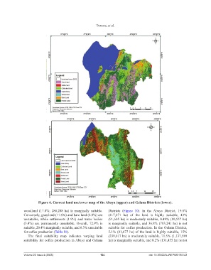
Figure 6. Current land use/cover map of the Abaya (upper) and Gelana Districts (lower).
woodland (17.8%; 286,208 ha) is marginally suitable. Districts (Figure 10). In the Abaya District, 19.6%
Conversely, grassland (11.6%) and bare land (8.8%) are (417,671 ha) of the land is highly suitable, 43%
unsuitable, while settlements (1.9%) and water bodies (91,605 ha) is moderately suitable, 0.49% (10,557 ha)
(3.4%) are permanently unsuitable. Overall, 72.9% is is marginally suitable, and 36.8% (783,241 ha) is not
suitable, 20.4% marginally suitable, and 6.3% unsuitable suitable for coffee production. In the Gelana District,
for coffee production (Table 10). 5.1% (81,677 ha) of the land is highly suitable, 15%
The final suitability map indicates varying land (239,017 ha) is moderately suitable, 71.5% (1,137,589
suitability for coffee production in Abaya and Gelana ha) is marginally suitable, and 8.2% (131,455 ha) is not
Volume 22 Issue 4 (2025) 164 doi: 10.36922/AJWEP025190143