
Page 170 - AJWEP-22-4
P. 170
Deresse, et al.
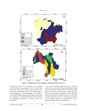
Figure 5. Soil pH map of Abaya (upper) and Gelana Districts (lower)
by cultivated land (18.2%; 289,045 ha), woodland The study calculated overall accuracy, user’s accuracy,
(17.8%; 282,589 ha), grassland (11.5%; 183,494 ha), producer’s accuracy, and the Kappa coefficient for land
bare land (8.8%; 140,142 ha), water bodies (3.4%; cover classification, with water bodies achieving 100%
71,143 ha), and settlements (2%; 31,813 ha) (Table 9). accuracy. The Abaya District had an overall accuracy
The classification revealed significant water bodies in of 88.76% and a Kappa coefficient of 0.8689, while the
Abaya and dominant forest land in Gelana, emphasizing Gelana District had an overall accuracy of 93.82% and
the importance of understanding land cover dynamics a Kappa coefficient of 0.9279. According to Mollick
for sustainable management, ecosystem health, and et al., a kappa coefficient of 0.882 indicates a strong
61
livelihoods. 60 agreement in land use/cover classification.
Volume 22 Issue 4 (2025) 162 doi: 10.36922/AJWEP025190143