
Page 121 - AJWEP-22-5
P. 121
Land–cover change in the Ngerengere River
a b
c
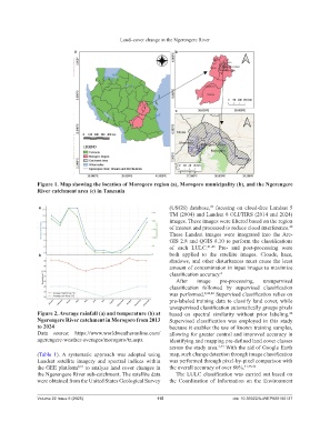
Figure 1. Map showing the location of Morogoro region (a), Morogoro municipality (b), and the Ngerengere
River catchment area (c) in Tanzania
a (USGS) database, focusing on cloud-free Landsat 5
39
TM (2004) and Landsat 8 OLI/TIRS (2014 and 2024)
images. These images were filtered based on the region
of interest and processed to reduce cloud interference.
40
These Landsat images were integrated into the Arc-
GIS 2.8 and QGIS 8.10 to perform the classifications
of each LULC. 41-43 Pre- and post-processing were
b both applied to the satellite images. Clouds, haze,
shadows, and other disturbances must cause the least
amount of contamination in input images to maximize
classification accuracy. 2
After image pre-processing, unsupervised
classification followed by supervised classification
was performed. 2,42,44 Supervised classification relies on
pre-labeled training data to classify land cover, while
unsupervised classification automatically groups pixels
Figure 2. Average rainfall (a) and temperature (b) at based on spectral similarity without prior labeling.
42
Ngerengere River catchment in Morogoro from 2013 Supervised classification was employed in this study
to 2024 because it enables the use of known training samples,
Data source: https://www.worldweatheronline.com/ allowing for greater control and improved accuracy in
ngerengere-weather-averages/morogoro/tz.aspx identifying and mapping pre-defined land cover classes
across the study area. 2,44 With the aid of Google Earth
(Table 1). A systematic approach was adopted using map, such change detection through image classification
Landsat satellite imagery and spectral indices within was performed through pixel-by-pixel comparison with
the GEE platform 9,31 to analyze land cover changes in the overall accuracy of over 80%. 41,45,46
the Ngerengere River sub-catchment. The satellite data The LULC classification was carried out based on
were obtained from the United States Geological Survey the Coordination of Information on the Environment
Volume 22 Issue 5 (2025) 115 doi: 10.36922/AJWEP025180137