
Page 185 - AJWEP-v22i2
P. 185
Topographic and watershed analysis
5. Discussion
Topographic analysis revealed that the Haditha Dam
basin is characterized by a mixture of flat plains and
steep hills, with slopes ranging from 0° to 30°. The
slope map Figure 9 shows that the steepest slopes are
concentrated in the northern part of the basin, while
the southern areas are mostly flat. This slope variation
significantly impacts water flow and erosion, with
steeper slopes experiencing faster runoff and higher
erosion rates. Bright areas (high values) indicate slopes
facing the light source, often north-facing slopes if the
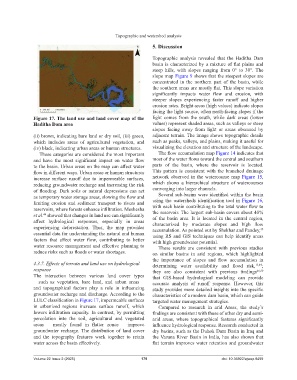
Figure 17. The land use and land cover map of the light comes from the south, while dark areas (lower
Haditha Dam area values) represent shaded areas, such as valleys or steep
slopes facing away from light or areas obscured by
(ii) brown, indicating bare land or dry soil, (iii) green, adjacent terrain. The image shows topographic details
which includes areas of agricultural vegetation, and such as peaks, valleys, and plains, making it useful for
(iv) black, indicating urban areas or human structures. visualizing the elevation and structure of the landscape.
These categories are considered the most important The flow accumulation map Figure 14 indicates that
and have the most significant impact on water flow most of the water flows toward the central and southern
to the basin. Urban areas on the map can affect water parts of the basin, where the reservoir is located.
flow in different ways. Urban areas or human structures This pattern is consistent with the branched drainage
increase surface runoff due to impermeable surfaces, network observed in the watercourse map Figure 15,
reducing groundwater recharge and increasing the risk which shows a hierarchical structure of watercourses
of flooding. Dark soils or natural depressions can act converging into larger channels.
as temporary water storage areas, slowing the flow and Several sub-basins were identified within the basin
limiting erosion and sediment transport to rivers and using the watersheds identification tool in Figure 16,
reservoirs, where forests enhance infiltration. Meshesha with each basin contributing to the total water flow to
et al. showed that changes in land use can significantly the reservoir. The largest sub-basin covers about 40%
44
of the basin area. It is located in the central region,
affect hydrological responses, especially in areas characterized by moderate slopes and high flow
experiencing deforestation. Thus, the map provides accumulation. As pointed out by Shekhar and Pandey,
45
essential data for understanding the natural and human using RS and GIS techniques can help identify areas
factors that affect water flow, contributing to better with high groundwater potential.
water resource management and effective planning to These results are consistent with previous studies
reduce risks such as floods or water shortages. on similar basins in arid regions, which highlighted
the importance of slopes and flow accumulation in
4.3.7. Effects of terrain and land use on hydrological determining water availability and flood risk, 13,49 ;
response they are also consistent with previous findings 46,50
The interaction between various land cover types that GIS-based hydrological modeling can provide
– such as vegetation, bare land, and urban areas – accurate analysis of runoff response. However, this
and topographical factors play a role in influencing study provides more detailed insights into the specific
groundwater recharge and discharge. According to the characteristics of a modern dam basin, which can guide
LULC classification in Figure 17, impermeable surfaces targeted water management strategies.
in urbanized regions increase surface runoff, which Compared to research in arid Areas, the study’s
lowers infiltration capacity. In contrast, by permitting findings are consistent with those of other dry and semi-
percolation into the soil, agricultural and vegetated arid areas, where topographical features significantly
areas – mostly found in flatter zones – improve influence hydrological response. Research conducted in
groundwater recharge. The distribution of land cover dry basins, such as the Duhok Dam Basin in Iraq and
and the topography features work together to retain the Varuna River Basin in India, has also shown that
water across the basin effectively. flat terrain improves water retention and groundwater
Volume 22 Issue 2 (2025) 179 doi: 10.36922/ajwep.8499