
Page 238 - AJWEP-22-6
P. 238
Qin, et al.
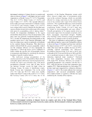
interannual variations of climate factors in counties and proximity of the Kunlun Mountains terrain uplift
cities are shown in Figure 7, with higher and least varied effect, showed a high value of precipitation rarely
temperatures in Bachu County (7.4–14°C), Tumushuke seen in the southern Xinjiang, which was probably
City (11.6–13.3°C), Makit County (13–14.2°C), and affected by strong convection in the mountainous
Zepu County (13.3–14.4°C). The regional differences areas or the residual water vapor of the Indian Ocean
in the multi-year mean temperatures in Shache County monsoon. The significant difference in precipitation
34
(−4.8–14.9°C) and Yecheng County (−25.7–14.5°C) between Shache County (33.9–89.7 mm) and the
were evident, which may be related to the fact that some neighboring Zephyr County (35.9–47.9 mm) may
regions of higher terrain in the northern part of the county be related to microtopography and oasis effects.
35
were prone to accumulating cold air during winter. Overall, precipitation in the region mainly relied on
32
Overall, the temperature distribution in the region weak water vapor from the westerly wind belt, while
showed three characteristics: first, the temperature in the basin topography exacerbated drought. Notably,
plain oasis area generally maintained between 11 and only Yecheng County formed a unique precipitation
14°C; second, the temperature fluctuated greatly in the pattern due to changes in the elevation gradient.
northern region close to the Tianshan Mountains; and The trend of temperature and precipitation changes
third, the temperature varied exceptionally with altitude under different land use types in the Yarkand River Basin
in the southern Kunlun Mountains. This distribution is shown in Figure 8. Farmland and bare land exhibited
pattern reflected both the general geographic context the largest increase (1.07°C and 1.03°C, respectively),
and the profound influence of local topography on while other types had the smallest decrease (0.74°C),
temperature. Follow-up studies can be conducted to reflecting regional temperature rise differences.
33
further clarify the specific role of topographic factors Precipitation increased from 35.01 mm to 49.03 mm,
in temperature distribution by combining the elevation with peaks of 68.52 mm and 80.00 mm in 2003 and 2005,
locations of specific weather stations. and a significant increase in other types (19.03 mm),
The multi-year average precipitation of the indicating improved water resources. Farmland
36
counties and cities in the Yarkand River Basin showed and forest temperature increases were correlated
noticeable spatial differences and local peculiarities. with steady FVC increases. Similarly, an increase in
Overall, the region was extremely arid, with annual grassland precipitation was consistent with the rise in
precipitation generally lower than 90 mm, below FVC, while the increase in bare land temperature may
the national average, except for high values in suppress FVC. High precipitation but fluctuating FVC
Yecheng County. In terms of distribution trends, in other land types suggested low utilization efficiency
Bachu County and Tumushuke City in the north (Figures 3, 7, and 8). The trends indicated that warming
(34.1–85.3 mm and 40.4–65.7 mm) were slightly temperatures and increased precipitation together
higher than Makit County in the south (31.8–61 mm), drove improvements in vegetation, with land use types
but Yecheng County (24.5–273.5 mm), due to the modulating the intensity of the response.
A B
Figure 7. Interannual variation of climatic factors in counties and cities of the Yarkand River Basin.
(A) Interannual variation in temperature factors by county and city. (B) Interannual variation in precipitation
factors by county and city area.
Volume 22 Issue 6 (2025) 232 doi: 10.36922/AJWEP025350269